Place name of the Month archive

Russian Revolution Centenary 30 January 2017

2017 is the centenary of the Russian Revolutions; the first of which took place in March 1917. The “February Revolution” actually began on March 8th and culminated in the abdication of the last Tsar of Russia, Nicholas II on March 15th, ending over 300 years’ rule by the Romanov dynasty.

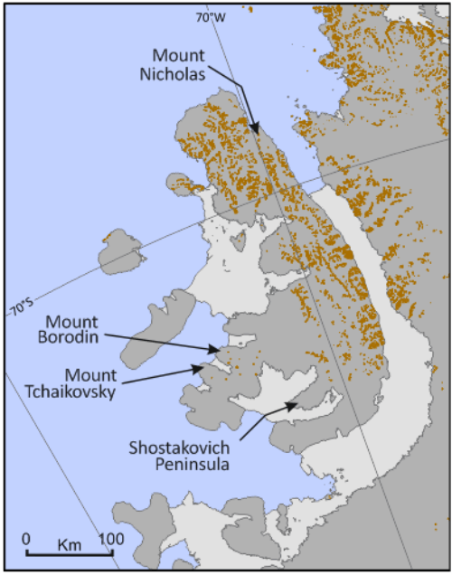
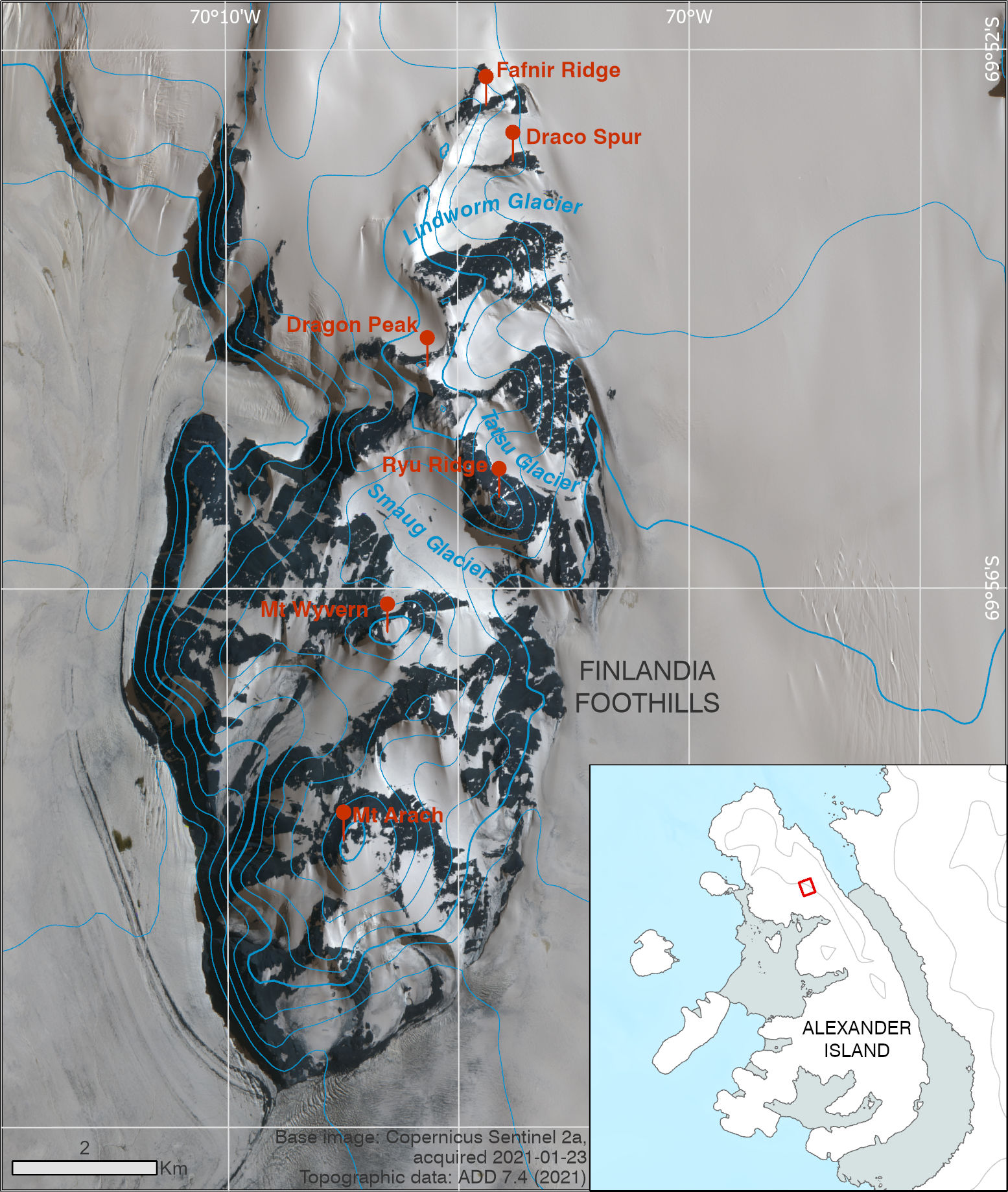
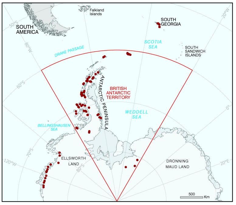
Key figures of Russian history are represented in Antarctica, many of whom are associated with Alexander Island, named after Tsar Alexander I who despatched the Russian Antarctic Expedition in 1819. Mount Nicholas (69° 21′ 56″ S, 69° 51′ 10″ W, Alexander Island), is named after the ill-fated Nicholas II. It was first seen by the French Antarctic Expedition in 1909 and surveyed by FIDS in 1948.

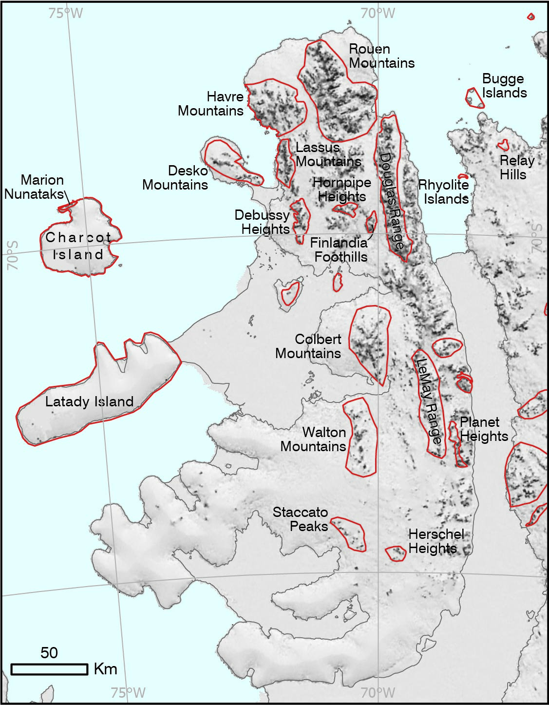
Other names associated with Russian history highlight its rich culture, including composers Tchaikovsky (Mount Tchaikovsky, 71° 22′ 27″ S, 73° 14′ 36″ W), Shostakovich (Shostakovich Peninsula, 72° 10′ 59″ S, 71° 19′ 59″ W) and Borodin (Mount Borodin, 71° 36′ 11″ S, 72° 37′ 38″ W). These are located alongside the names of other notable composers in this area.

Read More
Place-names around Alexander Island

Rothera Day 30 March 2017

May 3rd was Rothera Day, where Rothera’s role as the logistics hub in Antarctica and the exciting plans for future development were celebrated here at BAS. Rothera Research Station is located on Rothera Point (67° 34′ 10″ S, 68° 07′ 37″ W), Adelaide Island, named after John Rothera, FIDS surveyor for Horseshoe Island (1957-58) and Detaille Island (1958-59). It was first photographed by FIDASE and surveyed by John Rothera and Peter Gibbs in 1957-58 and its northern part was designated a SSSI (now ASPA) in 1986. The point forms the southern extent of Wright Peninsula (67° 27′ 47″ S, 68° 10′ 24″ W) named after Alan Wright, BAS surveyor at Adelaide base (1961-63).

Notable place names in and around the area are associated with the site’s history. Mackay Point (67° 32′ 14″ S, 68° 04′ 27″ W) was named for Donald Mackay, a BAS builder for Halley, Signy, and Rothera. Cheshire Island (67° 34′ 23″ S, 68° 07′ 29″ W) is named after Alan Cheshire who was a BAS radio operator at Faraday and Rothera stations from 1976-79. Similarly, Killingbeck Island (67° 34′ 19″ S, 68° 04′ 30″ W) is named for John Killingbeck, FIDS Base Leader for Deception Island 1961-62, BAS General Assistant for Adelaide Base in 1962-63 and later surveyor on the last dog journey, Alexander Island 1993-94.

Read More
Place-names around Wright Peninsula

Signy Station 1 June 2017

Signy (60° 42′ 29″ S, 45° 35′ 42″ W) was first established in 1947 as “Base H.” Signy Island was roughly charted by Capt. Matthew Brisbane, Master of the cutter Beaufoy, in early 1823 and later in 1912-13 by the whaler Kapt. P. Sørlle, who named the island Signy after his wife Fru Signy. Names in this region come from whaling, local wildlife and descriptions of features. Originally a key anchorage for whaling ships and from 1921 the site of a shore station, many place-names stem from whaling such as Waterpipe Beach and Pumphouse Lake (used for watering whaling ships); Factory Cove (site of whale processing plant); and Borge Bay (after Hans Borge, manager of the factory ship Polynesia). Cemetery Flats and Cove are testament to the hazardous work of whaling.

More recent names originate from the local wildlife. Elephant Flats (60° 42′ 14″ S, 45° 36′ 50″ W) was named after the elephant seals which haul out here, while Pup Cove (60° 42′ 11″ S, 45° 36′ 32″ W) was named for the first recorded birth of a fur seal pup on the island (in February 1977) since Signy station opened. Other names are descriptive; Changing Lake (60° 42′ 29″ S, 45° 37′ 08″ W), comes from how the lake has slowly changed size as the retaining glacier ice retreated. Close by, Limestone Valley (60° 42′ 11″ S, 45° 37′ 16″ W) is named from its exposure of limestone cliffs. The current Signy Island topographic map (2010) is due an update in the coming months – watch this space! For more information on place names and the Antarctic Place-names Committee, please see http://apc.antarctica.ac.uk/.

Read More
Place-names around Signy Station

Shackleton's Crossing 1 August 2017

BAS has recently published a new map of South Georgia, which features completely new, detailed mapping for the route of the crossing of the Island by Shackleton, Frank Worsley and Tom Crean in May 1916. This epic journey has inspired many names along the route.

The first difficult pass on their route was The Razorback (54° 09′ 13″ S, 37° 05′ 06″ W). This feature extends between the northern peak of the Trident and Sörlle Peak and is still a major obstacle to parties attempting the Shackleton route. The three men eventually crossed at the most northerly col, descending down to Compass Glacier (54° 09′ 51″ S, 37° 03′ 21″ W), named after Frank Worsley’s compass which was critical to use on the expedition.

They then crossed Crean Glacier and Nineteen-sixteen Snowfield (54° 09′ 53″ S, 36° 57′ 48″ W), named in commemoration of the crossing. Mistaking Fortuna Bay for Stromness Bay, they descended down the aptly named Turnback Glacier (54° 07′ 38″ S, 36° 50′ 38″ W) before retracing their steps and descending through Breakwind Ridge to Whistle Cove - hearing the steam whistle at Stromness reassured the party that they were within reach of safety.

After starting the final climb at Worsley Beach, Tom Crean discovered Crean Lake by breaking through its ice, and then the final obstacle on their journey involved a perilous clamber down what is now Shackleton Falls (54° 09′ 00″ S, 36° 44′ 28″ W) with the aid of just 15 m of rope, before descending Shackleton Valley and finally making contact with Thoralf Sörlle, manager at Stromness whaling station.

Read More
Placenames along Shackleton's route

Bird Island 1 October 2017

Bird Island (54° 21”S, 38° 02’ 30”W) was first discovered by Cook in early 1775 and named descriptively for the number of birds he saw there. The wildlife on the island have inspired other names in the area. Sooty Cove (54° 00′ 40″ S, 38° 02′ 24″ W), Wanderer Ridge (54° 00′ 31″ S, 38° 02′ 35″ W), Molly Hill (54° 00′ 51″ S, 38° 04′ 00″ W), Gony Point (54° 00′ 27″ S), Pio point (54° 01′ 03″ S, 38° 04′ 54″ W) and more are named after the local populations of Albratross species. More place-names come from other species present on the island, such as Macaroni Cwm (54° 00′ 07″ S, 38° 01′ 12″ W) named for the Macaroni penguin colonies present nearby; Fairy Point (54° 00′ 39″ S, 38° 04′ 36″ W), named for the fairy prion, and Gazella Peak (54° 00′ 12″ S, 38° 02′ 48″ W), named after a sub-species of fur seal which breeds in large numbers on the island.

Read More
Place-names around Bird Island

Mount Daynes 1 December 2017

Anyone who has done fieldwork in Antarctica with BAS is likely to have slept in a pyramid tent or towed a heavily-laden Nansen sledge. Since 1988 these trusted items of equipment have been made for BAS by Snowsled Ltd - designers and suppliers of polar equipment to many national polar research programmes and expeditions.

Mount Daynes is a locally prominent peak rising to 936 m at the head of Sjögren Inlet, NE Antarctic Peninsula . It’s named for Roger Daynes (b.1942), meteorologist and BC at Halley 1971-73, and then co-founder, owner and Director of Snowsled Ltd until his retirement in 2016. Other names associated with pioneers of overland and polar travel in the Nordenskjöld Coast area include Eliason Glacier (Eliason motor sledge), Weasel Hill and Pyke Glacier (Weasel tracked vehicle and its inventor), Mount Tucker (Tucker Sno-cat) and many more.

Read More
Place-names around Mount Daynes

Missing Places 1 February 2018

In a departure from tradition, this month’s place-name article highlights places that no longer exist; these are marked with an asterisk in the APC gazetteer and on the web-map. Due to the changing nature of the Antarctic landscape there are a number of features which have been renamed or flagged with an asterisk by the Antarctic Place-names Committee. This is partly in response to the changing face of the ice shelves, allied with increased remote sensing capabilities.

Given the recent exploration of Prince Gustav Channel by those on board the James Clark Ross, it is fitting to start with what was there before: The Prince Gustav Ice Shelf, which extended into Röhss Bay, James Ross Island. This ice shelf started retreating in 1945 and continued until its final breakup in February 2002, when the last remnants of the shelf broke away.

Similarly, the Wordie Ice Shelf formerly extended into Marguerite Bay, but gradually retreated and broke apart until 2004, when it had entirely disappeared. The newly-formed area has since been named Wordie Bay (69° 06’ 58” S, 67° 45’ W). The ice shelf retreat also revealed islands which were previously hidden: Buffer Island and Napier Island were revealed in 1989, having previously been considered Ice Rises in the Shelf.

Read More
Wordie Bay with Wordie Ice Shelf indicated

Thwaites Glacier 1 April 2018

The International Thwaites Glacier Collaboration was launched on Monday 30th April. This huge multidisciplinary project will study the glacier and its adjacent ocean region. While this area is outside the British Antarctic Territory, local place names and their origins can be found in the SCAR Composite Gazetteer of Antarctic

The Thwaites Glacier (106°45’W, 75°30’S), is located in the West Antarctic and flows into the Amundsen Sea. This extensive ice feature was named by the US-ACAN for Frederik T. Thwaites, glacial geologist and geomorphologist at the University of Wisconsin (1883-1961). The nearby Pine Island Glacier, focus of the iSTAR project, was named for the USS Pine Island, a seaplane tender and flagship of the task group of the US Navy Operation HighJump, which explored the area in 1946-47.

In the same vein, Bear Peninsula (111°W, 74°35’S) was named after the ship USS Bear. Reconnaissance flights were made from this ship in February 1940, leading to the discovery of the Walgreen Coast. This coast was named after Charles R. Walgreen, who assisted in equipping the Bear for the campaign of 1939-41. This expedition was led by R. Admiral Byrd, in relation to whom many places have been named such as Marie Byrd Land (named by Byrd after his wife), the nearby Byrd Subglacial Basin, and associated Byrd Surface camp, which will play a key role in the Thwaites project logistics.

Read More
Thwaites Glacier

Sunshine 1 June 2018

Given the perfect weather we’re having it seems only fitting that we highlight some sunny names found on our favourite cold continent. As many know, a “Dingle Day” is an Antarctic saying for a perfectly calm blue-sky day. This saying can be found in the place names on Snow Hill Island: Dingle Nunatak and Day Nunatak are named for Richard Dingle, BAS geologist, and Crispin Day, Field Guide for a BAS field party of the James Ross Island area in 1994-95.

On the continent, Sky-Blu (74° 51’ 08”S, 71° 34’ 54”W) is situated in Palmer Land, south of Mount Mende and Mount Lanzerotti. Sky-Blu is named after the Sky-Hi Nunataks, named for the US Project “Ski-Hi,” later “Eights Station.”

Disclaimer: MAGIC bears no responsibility if this article jinxes the weather.

Read More
Sky-Blu, Dingle and Day Nunataks along the Antarctic Peninsula

BAS Research Vessels 30 August 2018

With the launch of RRS Sir David Attenborough it seems fitting to highlight the other supply and scientific research vessels used by BAS over the years and noted in the APC Gazetteer. RRS John Biscoe was used by BAS from 1956 to 1991, and was the second Antarctic vessel to be named after John Biscoe, Master, RN (1794-1843) who landed on Anvers Island in 1832. Biscoe Bay (63°48’58”W, 64°48’ S) and Biscoe Islands (66°21’51”W, 66°01’57”S) are named after the famous explorer. Rothera’s Biscoe Wharf was named after the ship itself, which was the first vessel to use the new facility in 1991. The RRS Bransfield, built as a replacement to the RRS Shackleton (1955-69), was used from 1970 to 1999. She was named after Edward Bransfield, Master, RN who discovered the area now known as the Bransfield Strait and the first part of continental Antarctica seen by man, Trinity Peninsula.

These ships were replaced by our current vessels, RSS Ernest Shackleton and RRS James Clark Ross. Both named after famed explorers, their names are reflected in other areas of the continent such as Mount Shackleton (63°55’22”W, 65°12’28”S), and James Ross Island (57°54’W, 64°09’S). Finally, Sir David Attenborough has also got a place name in Antarctic – the Attenborough Strait runs between Charcot Island and Latady Island. This strait opened up following the partial break-up of the Wilkins Ice Shelf in 2009, and was named in 2010.

Read More
Names of BAS Research Vessels, noted in Antarctic Place names.

Thwaites Glacier Launch 1 December 2018

The Thwaites project ship relief will take place during the New Year with equipment and fuel being offloaded at the English Coast. This area was first mapped on the ground by the United States Antarctic Service (USAS, now USAP) in 1940, and named for the organisation’s Executive Secretary, Capt. Robert A. J. English. Stange Sound was first photographed and mapped by RARE in 1947, and named for Henry Stange, a contributor to the expedition. Carroll Inlet, where the ship relief is planned to be, was first observed from the air in 1940, and named from Arthur J. Carroll, Chief Photographer at the expedition’s “East Base.”

Nearby, Case Island (77° 57′ 35″ W, 73° 14′ 57″ S) is actually an ice rise in the Carroll Inlet itself, and was named for Francis S. Case, who obtained Government support to provide a ship for RARE. In the same vein, Spaatz Island (75° 06′ 48″ W, 73° 11′ 38″ S) is named for Gen. Carl Spaatz, Commanding General of USAAF, who arranged for provision of aircraft for RARE.

Read More
Place names around the English Coast.

Glaciologists 1 February 2019

John F. Nye (1923 – 2019) was a prominent figure in the field of glaciology. He was the first to apply plasticity to understand glacier flow and ice sheet behaviour, driving a new area of study within glaciology. Nye Glacier (67° 27’ 06”W, 67° 26’ 29”S) is named for him, and was first surveyed from Stonington Island by FIDS in 1948.

Other places on Arrowsmith Peninsula also have names of prominent glaciologists, such as Reid Glacier (67° 16′ 59″ W, 67° 25′ 59″ S) which is named after Harry Fielding Reid (1859-1944) who studied glacier flow and stratification in Alaska and the Alps. Vallot Glacier (67° 24′ 36″ W, 67° 20′ 31″ S) and Heim Glacier (66° 54′ 23″ W, 67° 26′ 49″ S) are named after Joseph Vallot (1854 – 1925) who first measured the surface velocity of a glacier over a long period, and Albert Heim (1849-1937), who was the first to consider glaciers from microstructure to world-wide distribution.

Read More
Place names highlighing significant glaciologists.

Navigation 1 April 2019

The RRS Shackleton has been a core part of BAS operations for the last 20 years and will leave BAS service at the end of April. The current focus on BAS ships and our reliance on them for core logistics and science underlines the importance (and difficulty) of marine navigation in Antarctic waters. This theme is highlighted in place names across the Territory.

Compass Island (68° 38′ 10″ S, 67° 47′ 09″ W), in Marguerite Bay, was surveyed by FIDS from Stonington Island in 1948-49. It was initially named Compass Inlet due to difficulties experienced with compass bearings during the initial surveys. Nearby, Northstar Island ( 68° 11′ 20″ S, 67° 06′ 02″ W) was named after USMS North Star, one of the USAS ships to visit the area in March 1940.

Instruments and methods used to calculate a ship’s location are noted in place names. Astrolabe Island (63° 18′ 58″ S, 58° 40′ 59″ W) and Astrolabe Needle (64° 06′ 54″ S, 62° 38′ 01″ W) are both named by after the FAE expedition ship L’Astrolabe, in operation in the 1837-40 expeditions. An astrolabe is a navigational instrument used to measure the altitude of celestial bodies above the horizon, and so provides a method to calculate latitude. Harrison passage (65° 54′ 32″ S, 65° 10′ 36″ W) is named after John Harrison (1693-1776), an English horologist who provided the first solution to determining longitude at sea. Maskelyne Passage (65° 51′ 00″ S, 65° 24′ 58″ W) is named for Nevil Maskelyne (1732-1811), English Astronomer Royal, who started the Nautical Almanac in 1767.

Read More
Place names highlighing features of navigation.

Greenland and the European Arctic 1 June 2019

MAGIC have recently released a brand-new map, “Greenland and the European Arctic” in conjunction with the Arctic Office. An important part of map creation is determining the appropriate naming to use for each region. This involved significant research into the Greenlandic language and work with the Language Secretariat of Greenland. Kalaallisut, West Greenlandic, has been the official language of Greenland since 2009.

Place names for the area are often descriptive and can be whole sentences when translated to English. An example of this is Qeqertarsuaq, which is the name of the island and of the largest town in the area – the literal translation is “Big Island.” In the same vein, Nanortalik, is the southernmost town in Greenland, and its name means “the place with Polar Bears.” Arguably the most well-known glacier in Greenland is Jakobshavn glacier. This fast-moving glacier is known in Greenlandic as Sermeq Kujalleq, where “sermaq” means “glacier,” and “kujalleq” means “southern” – it lies south of the town of Ilulissat, also known as Jakobshavn.

For more information about the Greenlandic language, please go to the Language Secreatariat of Greenland here: https://oqaasileriffik.gl/en

Read More
Greenlandic Place-names

Moby Dick in Antarctica 1 October 2019

August 1st was the 200th anniversary of Herman Melville’s birth. Testament to the variety of themes present in the APC gazetteer, there is a Moby Dick place name theme in Graham Land, northern Antarctic Peninsula.

Melville Glacier (62° 22′ 58″ W, 65° 28′ 41″ S), is named after the famous author. It was first surveyed by FIDS in 1947. Nearby, the Pequod Glacier (62° 19′ 42″ W, 65° 31′ 20″ S) is named after the whaling ship in the novel, with Mount Ahab (62° 10′ 40″ W, 65° 26′ 02″ S) named after its vengeful captain. Whitewhale Bastion (62° 29′ 50″ W, 65° 37′ 25″ S) rises between Starbuck Glacier and Pippin Peaks, named for the Pequod’s first mate and shipkeeper respectively.

Read More
Moby Dick place names in Antarctica

Norse Mythology in Dronning Maud Land 27 January 2020

Many names in Dronning Maud Land come from Norse mythology, and none more so than the Fenriskjeften region of the Drygalski Mountains. This area is named “the mouth of the wolf Fenris,” after the demonic wolf son of the god Loki. Looking at the topography, it is easy to see why; from the air the seven peaks in this range resemble a wolf’s jaws. The peaks surrounding the ice plateau Fenristunga, or “wolf’s tongue,” include Ulvetanna (“Wolf’s tooth”), Kintanna (“Wolf’s molar”), and Holtanna (“Hollow tooth”), and Mundlauga (“Mouth”).

The glacier adjacent to this mountain range is also named after Norse myths; Sigyn Glacier is named for Loki’s wife, and this area is called the Fimbulheimen, named after the great winter (“Fimbulvinter”) which marked the start of Ragnarok. At Ragnarok, the Norse version of the end of the world, the monstrous Fenris devours the sun and the moon and kills Odin, king of the gods, before being finally defeated by Vioarr, the Norse god of vengeance.

If you would like to learn more about place names in Antarctica, please see the SCAR Composite Gazetteer of Antarctica (CGA) here https://www.scar.org/data-products/place-names/

Read More
Place-names around the Fenriskjeften region of the Drygalski Mountains

Changes to Place Names 1 March 2020

As earth observation technology has advanced, so has the ability to assess the geography of an area using satellite imagery. This, alongside glacial retreat and other processes, has led to a number of place names needing a slight update!

During the latest update to the South Shetland Islands 1:200,000 map in 2019, a few sites were revealed to be different features than were initially thought. Gooden Point (61°59′ S, 58°32′20″ W) on King George Island was found to actually be an island, having previously been identified as a point. This feature was named after K.R. Gooden, Base Leader at Admiralty Bay in 1951. Similarly, on Robert Island, Kitchen Point was originally named Punta Labb by the CAE and later named Kitchen Point after Capt. Joseph Kitchen, master of the sealing ship Ann, who visited the South Shetland Islands in 1821-22. It has been identified as an island in the latest coastline update.

The South Shetland Islands 1:200,000 map is available from the British Antarctic Survey Mapping and Geographic Information Centre.

Read More
Changes to Place Names in the South Shetland Islands

Isolated Places 1 May 2020

We are no strangers to isolated places or social distancing here at BAS, with some of us living and working in some of the most remote places on Earth.

There are a number of place names that highlight this across the continent. Desolation Island (62° 27′ 28″ S, 60° 20′ 48″ W), off Livingston Island, is so named for its inhospitable appearance. Also in the South Shetland Islands, Retreat Bluffs (62° 09′ 19″ S, 58° 12′ 38″ W) was named after the retreat of Stwosz Icefall in 1998. Further South, Exile Nunatak (70° 32′ 34″ S, 70° 52′ 37″ W) was spotted in 1947 by the Chilean Antarctic Expedition (CAE) on Alexander Island, and named for its isolated position.

It is not all bleak though; rather poetically, FIDS spotted Lonely Rock just off of James Ross Island during an expedition from Hope Bay in 1945. There is also a Mount Hopeful on King George Island, and of course, Mount Hope, which was discovered to be the highest mountain in BAT, at 3,239 m.

Read More

200th Anniversary of the Royal Astronomical Society 1 August 2020

The Royal Astronomical Society (RAS), founded in 1820, encourages and promotes the study of astronomy, solar-system science, geophysics and closely related branches of science. Its headquarters in Burlington House has an important library and archive. The Society had a notable collection of scientific instruments, but this was largely dispersed to museums in the 1970s. Many Presidents of the RAS are recognised in Antarctic Peninsula region place-names.

Nineteenth century astronomers played an important role in the development of the navigational techniques and instruments vital for early naval exploration of the region: Sir George Airy, Airy Glacier, leading figure in the development of Greenwich Observatory and the Greenwich Prime Meridian; Francis Baily, Baily Head, promoter of gravity studies and reform of the nautical almanac; Sir John Herschel, Cape Herschel, polymath with many achievements, including cataloguing the stars and astronomical bodies of the southern hemisphere.

Others are recognised in a place-name theme for astronomers and their discoveries on southern Alexander Island: John Couch Adams, Adams Nunatak, codiscoverer of Neptune and promoter of the Greenwich Prime Meridian; Sir Frederick Herschel, Herschel Heights, discoverer of Enceladus and Mimas, satellites of Saturn; William Lassell, Lassell Glacier, discoverer of Ariel and Umbriel, satellites of Uranus, and Triton, satellite of Neptune; Sir Bernard Lovell, Lovell Glacier, first Director of Jodrell Bank Observatory.

Read More
Astronomers are recognised in different parts of the Peninsula

Blaiklock Island 1 October 2020

Named for Kenneth Blaiklock, pioneering surveyor who died at the end of September 2020 aged 92. He was a surveyor at Stonington 1948-50, including surveying the Dion Islands - at that time site of an emperor penguin colony, and the area around Blaiklock Island, November 1949. He later worked at Hope Bay 1952-54, but is best known as Surveyor on Sir Vivian Fuchs’ 1955-58 Commonwealth Trans-Antarctic Expedition. He was driver of one of two dog sledges to reach the South Pole for the first time since Amundsen in 1911, undertaking reconnaissance surveys along the route including the western end of the Shackleton Range.

Blaiklock Glacier, Shackleton Range (80° 34′ 59″ S, 29° 39′ 58″ W) was named by the APC in 1962. He joined a Belgian Antarctic Expedition 1959-61 and worked for BAS in the 1960s, doing a final summer in 1965. He was awarded the Polar Medal with third clasp, and OBE, and it is unusual for a person to have two place names in different areas.

Read More
Extract from BAS 1:250,000 scale map, Adelaide Island and Arrowsmith Peninsula.

Antarctic Place Names from Ireland 1 March 2021

Contributed by Robert Headland, Scott Polar Research Institute

On 17 March, St Patrick’s Day, 2021 there are at least 75 names in Antarctica and the sub-Antarctic islands named for 45 persons of Irish birth. The names date from early expeditions through to living scientists working in Antarctica.

Twelve names commemorate Sir Ernest Shackleton, born in Co. Kildare, covering most regions of the continent (eg Shackleton Range), South Georgia, and an oceanic feature, as well as RRS Sir Ernest Shackleton.

Other notable names include:

  • Bransfield Strait, and three other features, named after Edward Bransfield, born in Co. Cork, (as well as RRS Bransfield, BAS ship from 1970 to 1999).
  • Crean Glacier, South Georgia, and two other features, for Thomas Crean, born Co. Kerry, member of Shackleton’s South Georgia crossing; also McCarthy Island, South Georgia, Timothy McCarthy, aboard the James Caird, born Co. Cork.
  • Cape Crozier; Ross Island, and destination for ‘The Worst Journey in the World’, Francis Crozier, Co. Down, Captain of HMS Terror.
  • Storey Glacier; South Georgia, Prof. Bryan Storey, born Dublin, BAS geologist and later Director of Gateway Antarctica, New Zealand.

Names for prominent people who never visited Antarctica include:

  • Boyle Mountains; Graham Land, Robert Boyle, Co. Waterford, chemist and founding member of the Royal Society.
  • Estación Brown; Antarctic Peninsula (Argentine summer station), Admiral William Brown, Co. Mayo, leading figure in Argentine independence and founding of the Argentine Navy.
  • Ferguson Ridge; East coast of the Antarctic Peninsula, Harry Ferguson, Co. Down, pioneer of overland mechanical transport, notably the Ferguson Tractor, which reached the South Pole in 1958.
  • Shamrock Hill; South Sandwich Islands, was used for a survey station on St Patrick’s Day, 1964.
  • Clarsach Glacier; northern Alexander Island, has the shape of a clarsach (Irish harp).

The full list of names are:

  • Barcroft Islands
  • Beaufort Island
  • Bingham Glacier
  • Boyle Mountains
  • Bransfield Basin
  • Bransfield Island
  • Bransfield, Mount
  • Bransfield, Rocks
  • Bransfield Strait
  • Brown, Estacion
  • Clarsach Glacier
  • Crean Glacier
  • Crean Lake
  • Crean, Mount
  • Croker Passage
  • Crozier, Cape
  • Crozier, Mont
  • Crozier Point
  • Dalton Glacier
  • Dunlop, Cape
  • Dunlop Island
  • Emerald Island
  • Farrington Island
  • Ferguson Ridge
  • Ferrar Glacier
  • Forde, Mount
  • Gamble Cone
  • Gamble Glacier
  • Grubb Glacier
  • Gwynn Bay
  • Gwynn, Mount
  • Haskard Highlands
  • Herdman, Cape
  • Herdman Bank
  • Herdman Rocks
  • Horne Nunataks
  • Humphrey Lloyd, Mount
  • Irlandaise, Baie
  • Iveagh, Mount
  • Johnston, Mount
  • Johnston Passage
  • Johnston’s Point
  • Keohane, Mount
  • McCarthy Island
  • McCarthy, Mount
  • M’Clintock Bastion
  • McClintock, Mount
  • McIlroy Peak
  • McNeile Glacier
  • Manahan Peak
  • Mateer, Mount
  • Mauger Nunatak
  • Meares Cliff
  • O’Cain Point
  • Parsons Peak
  • Plunket Point
  • Ranfurley Point
  • Rea Peak
  • Robinson, Mount
  • Sabine Glacier
  • Sabine, Mount
  • Shackleton Canyon
  • Shackleton Coast
  • Shackleton Falls
  • Shackleton Fracture Zone
  • Shackleton Gap
  • Shackleton Glacier
  • Shackleton Icefalls
  • Shackleton Ice Shelf
  • Shackleton Inlet
  • Shackleton, Mount
  • Shackleton Range
  • Shackleton Valley
  • Shamrock Hill
  • Shannon Point
  • Spiller Cove
  • Storey Glacier
Read More
Map showing Antarctic place names from Ireland.

Antarctic Place Names honour James Clark Ross 1 May 2021

The RRS James Clark Ross is named after Admiral Sir James Clark Ross, R.N., Royal Navy explorer, and there are many places named in honour of him across the continent as well as on South Georgia and in the Arctic.

Within BAT, James Ross Island (64° 09’ S, 57° 45′W) was roughly charted by Ross during the 1839-1843 Ross Expedition and was originally shown as part of Trinity Peninsula, Palmer Land. It was further surveyed by SwAE in 1903 and determined to be an Island, then confirmed by FIDS in 1945-47.

The Ross Dependency comprises the sector of the continent between 160°E, and 150°W, south of 60°S. Within the Dependency contains the Ross Ice Shelf, Ross Island and Cape Ross, all named after the explorer. The Ross Ice Shelf was discovered on January 28, 1841 by Sir James Clark Ross, who mapped the ice front eastward to 160°W.

Read More
Map showing Antarctic place names honouring James Clark Ross

Euros 2020 1 July 2021

There is a strong correlation between Antarctic place-names and the countries represented at the Euro 2020 football tournament.

This is perhaps not so surprising, given the involvement of European countries in the exploration of Antarctica. At the time of writing, the semi-finalist teams are: Italy (Italia Valley, King George Island); Spain (Spanish Point, Livingston Island); England (English Strait, South Shetland Islands) and Denmark (there are no Denmark names, but there are Jutland Glacier, Victoria Land, and Skagen Point, Kemp Land) – see the map for the locations of these landmarks.

For the other 21 teams at the tournament, only Hungary, North Macedonia, Portugal and Slovakia do not have a related place-name. Wales is represented by Wales Glacier (Victoria Land) and several ‘Prince of Wales’ features, and Scotland by Scotia Bay, South Orkney Islands (after the Scotia, ship of the Scottish National Antarctic Expedition 1902-04) as well as the Scotia Sea.

Nations involved in early exploration – Belgium, France, Germany, Russia, and Scandinavian countries – are all present. Other countries less associated with Antarctic exploration and mapping include Switzerland (Switzerland Island, George V Land) and Austria (Österreichspitze, Dronning Maud Land). Ukraine has Kiev Peninsula (Graham Land), whilst Netherlands only has Holland Glacier (named after Sir Sidney Holland, PM of New Zealand) and finally, Turkey has Turks Head (Ross Island).

Read More
Map showing Antarctic place names related to Euro 2020 competitors

There be Dragons! 1 September 2021

Place names in Antarctica are often chosen around a theme for each area. An interesting example of this effect is in the Finlandia Foothills, Alexander Island. This area had not been visited prior to January 2018, and so this theme was used as a nod to older maps where uncharted areas were decorated with dragons and other mythical beasts.

Dragon Peak is the highest point of the Finlandia Foothills, while Lindworm and Wyvern are types of dragons in mythology. Arach, Draco, Ryu and Tatsu are Gaelic, Latin, Sino-Japanese and Japanese for dragon, respectively. You will be familiar with Smaug, named after the infamous dragon of JRR Tolkien’s The Hobbit (1937).

Read More
Map showing the dragon name theme in Alexander Island, Antartica

Centenary of the Death of Sir Ernest Shackleton 1 January 2022

5 January 2022 marked the centenary of Sir Ernest Shackleton’s death. The explorer has been commemorated in place-names across South Georgia and the Antarctic; there are over 250 place names either associated with Shackleton himself or related to his expeditions.

Many place names in South Georgia honour Shackleton and the famous crossing of 1916, where Shackleton, Thomas Crean and Frank Worsley travelled from King Haakon Bay to Stromness Bay in the first crossing of the interior of South Georgia, to save their remaining crew trapped on Elephant Island after their ship was crushed by sea-ice. The team started their crossing in what is now known as Shackleton Gap, and ended their traverse at Shackleton Valley where they made contact with those at Stromness whaling station. Features along their route are named after the expedition, such as Compass Glacier, after Frank Worsley’s compass, Crean Glacier, Worsley Beach and Nineteen-Sixteen Snowfield, commemorating the achievement.

Read More
Map showing place names related to Shackleton across South Georgia

Antarctic Neighbours - Akademik Vernadsky Station 1 March 2022

This issue we highlight our neighbours on the Antarctic Peninsula: Akademik Vernadsky Station on Galindez Island, operated by Ukraine. Previously UK’s Faraday station for almost fifty years, it was handed over to our polar colleagues in 1996. This is the only Ukrainian Antarctic station and is named after mineralogist Vladimir Vernadsky, first president of the National Academy of Sciences of Ukraine. Nearby, the Kyiv Peninsula is named after the capital city of Ukraine, in connection with the Ukrainian Antarctic base.

Vernadsky Station supports a wide range of scientific activity and operates year-round, with twelve wintering staff. Over summer the station supports up to twenty-four staff members at a time. This station has the longest continual meteorological observations on the continent (logged daily since 1947), and scientists based there study biological, geophysical, geological, processes.

The Noosphere icebreaker (previously the UK’s RRS James Clark Ross) set off on its first expedition from Odesa to Antarctica in January this year. The term Noosphere was popularised by Verdansky himself, and described as the development of humankind’s rational activity in biospheric development.

Read More
Map showing place names related to Ukraine across the Antarcitc Peninsula

World Penguin Day 1 May 2022

April 25th was World Penguin Day, and of course our favourite Antarctic locals have places named after them across the continent. Penguin Island, off King George Island, was first charted by Bransfield in January 1820 and was named after the “numerous penguins which disputed the landing party” (Bone, 1821 describing the expedition).

Penguin Bight and Penguin Point, Seymour Island was named after the penguin colonies first observed there by Larsen 1843, and named Pinguinbucht and Pinguinenkap respectively.

Penguin Point, Coronation Island, was charted by Powell in December 1821, and named for the penguin colonies found there. Nearby, Penguin Highway on Signy Island was surveyed by FIDS in 1947-50 and named for the demarcation line between colonies of penguins and areas inhabited by fur seals.

Finally, Emperor Island, off Adelaide Island, is named descriptively after the Emperor Penguin colony that was found by FIDS in 1948.

Read More
Map showing place names related to penguins across the Territory

Undersea Names in Antarctica 1 July 2022

A new version of the International Bathymetric Chart of the Southern Ocean has recently been released and is the most detailed grid of the Southern Ocean. The data showcases the shape of the southern ocean floor, but also highlights the need for place names in the region.

The UK Antarctic Place-names Committee considers names within 12 nautical miles of the coast or ice shelves that are important to navigation. Features further offshore are dealt with by the International Hydrographic Organisation. Undersea feature names are managed by GEBCO (General Bathymetric Chart of the Oceans); they have a digital gazetteer and a web-map to view and download information here.

Read More
Map showing undersea place names in the Southern Ocean

Scottish Names in Antarctica 1 September 2022

This month, the UK Antarctic Place-names Committee presented at the UK Antarctic Science Conference in Edinburgh, highlighting the Committee’s work and how scientists can get involved in the application process.

Did you know that there are over 20 names associated with Scotland across Antarctica? There are also over 40 Scots named, commemorating engineers, physicists, geographers, glaciologists, chemists and many more.

South Shetland Islands and South Orkney Islands were first sighted by William Smith in 1819 and by Powell in 1821 respectively and were so named as the islands lie in about the same latitude as the Scottish Isles in the Northern Hemisphere.

Finally, Edinburgh Hill is named for the Scottish capital. Dundee Island and the Firth of Tay were first sighted by Ross in 1842 and named for the home port of the expedition. Inverleith Harbour is named after the ‘mouth of the river Leith’ in Gaelic.

Read More
Map showing names associated with  Scotland in Antarctica

Weather names in Antarctica 1 November 2022

October marks the start of the next Antarctic science season with the wintering teams welcoming people back to stations for the first time since last call in May. Weather plays a significant role in travel in the Antarctic and having good weather conditions is vital for safe travel both to the continent and further deep field.

There are several places named after weather conditions across the Territory. Features Dingle Nunatak and Day Nunatak were co-located to highlight the term “Dingle Day” – a clear blue-sky day in Antarctica. Sunshine Glacier was named as, even on cloudy days, there is usually a patch of blue sky above the area that shines a patch of sunlight on the glacier.

Slightly inauspiciously, Weather Guesser Nunataks were named by an aerographer following the US Antarctic Peninsula Traverse in 61-62. Fingers crossed for good weather and dingle days for the coming season!

Read More
Map showing names associated with  weather in Antarctica

Happy New Year 1 January 2023

Happy New Year and best wishes from all of us at the UK Antarctic Place-names Committee. This time of year is always a good opportunity for reflection and a fresh start, and there are names across the continent which share this theme.

Start Point, off Livingston Island, South Shetland Islands, was first charted by Bransfield in 1820 and named Start or The Start as it was the first area where their operations commenced. Start Hill, the highest point on the ridge, Ray Promontory, was named in association with the Point. Nearby, New Plymouth is named after Plymouth, Devon. Similarly, Cape New Haven on Low Island was named after New Haven, Connecticut, home port of many of the 19th Century sealing vessels.

Read More
Map showing names associated with  a fresh start in Antarctica

Antarctic Wildlife 1 March 2023

Friday 3rd March was World Wildlife Day, celebrating all wild animals across the planet. Antarctica’s unique environment and near pristine wilderness is home to many species of fauna and these are highlighted by place-names across the continent.

Across British Antarctic Territory, there are over 20 places named in relation to penguins, including Penguin Island, Penguin Point (Coronation Island), and Penguin Bight (Snow Hill Island). More specifically, Chinstrap Cove and Emperor Island were named after the penguin colonies that reside in the regions. Similarly, Avian Island is named for the populations of bird that nest there, and Shag Rock is named for a colony of blue-eyed shags.

Seals and whales are also highlighted: Sea Leopard Patch, Seal Islands and Whale Bay are just a few examples of places named after the local wildlife. On a smaller scale, Midge Lake is named for the abundance of a flightless midge found at the lake, which is endemic to the Antarctic Peninsula and South Shetland Islands

Read More
Map showing names associated with Antarctic wildlife

Zavadovski Island 1 July 2023

Preparation for the upcoming field season is well underway with BAS operations and logistics coordinating visits to a wide variety of sites. This is the first of a series of place names articles where we’ll be highlighting some of the interesting places staff will be researching.

The first fieldwork site is Zavodovski Island, which rises to an active volcanic cone. The northern-most of the South Sandwich Islands, it was first charted by the Russian Antarctic Expedition (RAE) on 4th January 1820, and named after Kapitan-Leytenant Ivan Ivanovich Zavodovskiy, Second-in-Command of the expedition ship Vostok and member of the party which landed on the island on 5th January 1820. Since then, it has been charted by various Antarctic expeditions including by HMS Protector in 1962 and 1964. They applied a group of descriptive names the island, including Stench Point, Noxious Bluff and Asphyxia Plain, all in reference to the smell of volcanic fumes emitted from the crater!

The island is soon to be visited again by a team from BAS. This Darwin Plus funded project aims to census penguin colonies and survey terrestrial biodiversity using drones, manned aerial and satellite images. They will also track penguin movements at sea throughout their annual cycle. This will involve a 3-week tented expedition to the island supported by a charter yacht and an overflight by the RAF A400M transport plane. Results will inform the South Sandwich Island Terrestrial Protected Area action plan and the revision of the SGSSI Marine Protected Area management plan.

Read More
Map showing names across Zavadovski Island

Seymour Island 1 September 2023

Preparation for the upcoming field season is well underway with BAS operations and logistics coordinating visits to a wide variety of sites. We’ll be highlighting some of the interesting places staff will be researching as the season starts.

Seymour Island will be visited in the 23/24 season. It was first sighted by Ross in 1843 and named after Rear Admiral Sir George Francis Seymour RN and thought to be a cape until 1892 when it was charted by Larsen. During 1892-1893 Larsen made landings on the island and the first recorded fossils from the Antarctic were collected.

Further south, Fossil Bight is so named after the numerous fossils found in the region by the USARP and Argentine researchers in 1982. Cape Wiman is named after Carl Johan Josef Wiman, Professor of Palaeontology (1911-33), who worked on fossils collect by the Swedish Antarctic Expedition (SwAE). Related to that expedition, Bodman Point is named for Dr Gösta Bodman, member of the sledge party of SwAE in 1902-03. Similarly, Bertodano Bay is named after J. López de Bertodano of the Argentine corvette Uruguay, which rescued the SwAE in 1903.

Read More
Map showing names across Seymour Island

Union Glacier 1 November 2023

The field season has started with BAS operations and logistics coordinating visits to a wide variety of sites. We’ll be highlighting some of the interesting places staff will be researching as the season progresses.

The Union Glacier region will be visited in the 23/24 science season to test rock and ice drills that will be used for future field deployments. This work will contribute to our understanding of the history of the West Antarctic Ice Sheet (WAIS) over past interglacial periods.

Union Glacier was mapped by USGS from surveys and USN air photos and named with reference to Heritage Range. This large mountain range stretched for over 100 miles and was most likely first sighted in 1935 during Ellsworth’s trans-Antarctic flight. The range was named by the US Advisory Committee on Antarctic Names as the features within the range have received names relating to American heritage. Examples of this are seen in the region the field team will be travelling; Collier Hills are named for Robert Collier, member of the 1962-63 University of Minnesota Ellsworth Mountains Party. Donald and Ronald Ridges are named for Donald Wilson and Ronald Taylor, members of the Little America V Station in 1957 and 1958. Similarly, Schanz Glacier is named for Lt. Cdr. Schanz, supply officer with USN during Deep Freeze, 1965.

Read More
Map showing names across Union Glacier region

Marguerite Bay 1 January 2024

The 23-24 field season is well underway and we’re highlighting some of the interesting places staff will be studying. One team operating out of Rothera Research Station is studying the differences in ecology, distribution and foraging success of crabeater seals along the western Antarctic Peninsula. The field team used aerial photography from a Twin Otter of ice seal habitat in Marguerite Bay and Crystal Sound.

Marguerite Bay was surveyed as part of the French Antarctic Expedition (FAE) in 1909, and named for the wife of Dr Charcot, Commander of FAE. Ryder Bay was roughly mapped during the same the French Antarctic Expedition in 1909 and again by the British Graham Land Expedition (BGLE) in 1936. It was surveyed again by Falkland Islands Dependencies Survey (FIDS) in October 1948 and named after Major Lisle Ryder, who served in the British Graham Land Expedition (BGLE).

Further north, Crystal Sound was first sighted by the FAE in 1908-10, and first traversed by The Penola as part of the BGLE, after air reconnaissance, in February 1936. Most of the Sound and its islands were photographed by Falkland Islands and Dependencies Aerial Survey Expedition (FIDASE) in 1957, and the Sound named after the group of local place names for scientists who studied the structure of ice crystals.

Read More
Map showing names across Marguerite Bay

Pensacola Mountains 1 March 2024

The 23-24 field season is nearly complete, and we’re highlighting some of the interesting places staff have been studying. One team operating out of the Pensacola Mountains used a portable drill system to drill through ice close to the mountains, to collect a series of subglacial rock cores. The team will then use geochronological methods to establish if the rock has previously been exposed due to the ice sheet being smaller, and for how long this was the case.

The Pensacola Mountains form part of the Transantarctic Mountain range and were first photographed from the air by the US Navy in 1956. They are named after the US Naval Air Station at Pensacola, Florida. The Neptune Range forms the central part of the Pensacola Mountains and is named for the aircraft used during the 1956 reconnaissance flights – the P2V-2N Neptune aircraft.

Many other features in the area are named for those involved in the USN air photography campaign and subsequent field campaigns in 1961-65. These include Nelson Peak, named for Willis H Nelson, USGS geologist, and Miller Valley, named for Lieut. Donald R. Miller, USN, pilot of R4D aircraft with Squadron VX-6, who provided logistic support for the USGS field party in the area, summer 1963-64 .

Read More
Map showing names across the Pensacola Mountains